Enjoy and contribute!
| Find the best spots |
|
|
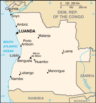
 Angola
Africa
Location: Southern Africa, bordering the South Atlantic Ocean, between Namibia and Democratic Republic of the Congo
Geographic coordinates: 12° 30' S, 18° 30' E
Coastline km: 1,600 km km
Climate: semiarid in south and along coast to Luanda; north has cool, dry season (May to October) and hot, rainy season (November to April)
Terrain: narrow coastal plain rises abruptly to vast interior plateau
Elevation: lowest point: Atlantic Ocean 0 m
highest point: Morro de Moco 2,620 m
Natural hazards: locally heavy rainfall causes periodic flooding on the plateau
Currency: kwanza (AOA)
Population: 12,127,071 (July 2006 est.)
Languages: Portuguese (official), Bantu and other African languages
Capital: Luanda
Divisions: 18 provinces (provincias, singular - provincia); Bengo, Benguela, Bie, Cabinda, Cuando Cubango, Cuanza Norte, Cuanza Sul, Cunene, Huambo, Huila, Luanda, Lunda Norte, Lunda Sul, Malanje, Moxico, Namibe, Uige, Zaire
More details
| Jan | Feb | Mar | Apr | May | Jun | Jul | Aug | Sep | Oct | Nov | Dec | |
|---|---|---|---|---|---|---|---|---|---|---|---|---|
| Climate | ||||||||||||
| Air temp. | ||||||||||||
| Water temp. | ||||||||||||
| Wind consistancy | ||||||||||||
| Wind force | ||||||||||||
| Best season | 
|

|

|

|

|

|

|

|

|

|

|

|
Additional map

Wanna add some info about Angola? Let us know...
This is an interactive map! Use controls to pan and zoom this map.
- kite sessions (0)
- trips (0)
- Photos (4)
- Videos (0)
- Favourite
-
Your favourites and future spot lists
Spots
| Spots (2) | Quality | Experience | Type | Amenities | ||
|---|---|---|---|---|---|---|
| Buraco | - / - | Everyone | Lagoon | |||
| Mussulo Lagoon | 4 / - | Intermediate | 
|
 Comments
Errors, Feedback
If you want to add new information or you have found errors on this country, Send us feedback.


